How ToF Technology Enables Accurate 3D Mapping, UAV LiDAR, and SLAM

How Does ToF Technology Help UAVs and Robots Measure Distances and Build 3D Maps?
From Historical Distance Measurement to Modern 3D Spatial Perception
Measuring distance and mapping the world have always been essential to human civilization. From ancient Babylonian maps to quadrant instruments for celestial height measurement, and now to modern mobile mapping systems using ToF, LiDAR, and SLAM, distance measurement technology has continually evolved.
This article explores how TOF (Time-of-Flight) technology enables precise distance measurement, localization, and 3D mapping, supporting applications in UAV surveying, urban 3D modeling, autonomous navigation, planetary exploration, and industrial inspection.
The Evolution of Maps and Distance Concepts
From Ancient Maps to Coordinate Systems
The earliest known maps, such as those from ancient Babylon, represent humanity’s first attempts at spatial understanding. Although not precise, they laid the foundation for modern geospatial information systems (GIS).
Later, global coordinate systems, such as latitude 0, longitude 0, provided standardized frameworks, forming the basis of:
-
Modern navigation systems
-
Autonomous vehicle localization
-
Geographic and planetary mapping
Early Measurement Tools: Quadrants and Levels
Before electronic sensors, humans relied on instruments for distance and height estimation:
-
Quadrant instruments: Measured celestial altitudes to estimate latitude
-
Water level detectors / level sensors: Ensured construction and mapping accuracy
These tools established the fundamental logic of measurement → localization → mapping, which remains central to modern 3D spatial systems.
From Static Maps to Mobile Mapping
Static maps are no longer sufficient; modern applications require dynamic, real-time environmental perception.
Mobile mapping systems now integrate:
-
Cameras
-
IMUs (Inertial Measurement Units)
-
GNSS / GPS modules
-
ToF or LiDAR sensors
Applications include:
-
Urban 3D modeling and digital twins
-
Road, bridge, and infrastructure inspection
-
Autonomous navigation and robotics
-
Industrial site digitalization

What Is Time-of-Flight (ToF) Technology?
Time-of-Flight (ToF) is a distance measurement method that calculates the distance by measuring the time light takes to travel from a sensor to an object and back.
-
Emits modulated infrared light or laser pulses
-
Measures round-trip travel time
-
Generates per-pixel depth data / depth maps
Key Advantages of ToF Technology
-
High real-time performance – Depth data in milliseconds for dynamic scenes
-
High measurement accuracy – Millimeter- to centimeter-level precision
-
Strong resistance to ambient light – Reliable indoors and outdoors
-
Efficient computation – Short processing pipelines, low latency
ToF is widely used in:
-
RGB-D cameras for 3D vision
-
Robot navigation and obstacle avoidance
-
SLAM mapping and autonomous vehicles
-
Industrial measurement and inspection
-
AR/VR spatial perception
-
Face and gesture recognition
ToF as the Core Engine of Modern Distance Measurement
By leveraging the constant speed of light, ToF sensors directly convert time measurements into high-precision distances, making them indispensable for:
-
3D spatial perception
-
Digital twin construction
-
Autonomous navigation
-
Mobile mapping platforms
ToF technology forms the bridge between the physical and digital worlds, enabling high-accuracy, real-time, and scalable 3D measurements.
Advantages of ToF Technology in 3D Mapping
1. High-Precision Distance Measurement
-
Millimeter- to centimeter-level accuracy
-
Reliable for both short-range industrial inspections and large-scale terrain mapping
-
Supports engineering measurement, robotics, and scientific research
2. Real-Time Continuous Measurement
-
Millisecond-level updates while moving
-
Critical for:
-
UAV surveying
-
SLAM-based navigation
-
Autonomous vehicles
-
Mobile mapping platforms
-
3. Environmental Robustness
-
Active infrared / laser illumination minimizes dependence on ambient light
-
Works in low-light, shadowed, nighttime, and outdoor scenarios
-
Essential for UAV LiDAR, road inspection, and maritime distance measurement
4. Full 3D Spatial Perception
-
Per-pixel depth maps generate point clouds and 3D models
-
Enables:
-
Urban 3D modeling
-
Industrial spatial layouts
-
Building digitization
-
AR/VR scene reconstruction
-

ToF in UAV LiDAR: Revolutionizing Aerial Mapping
Mounting ToF-based LiDAR sensors on UAVs enables high-accuracy aerial distance measurement, transforming drones into 3D mapping platforms.
Applications include:
-
Large-scale terrain scanning and urban 3D modeling
-
Forest canopy height and vegetation structure analysis
-
Mining, construction, and industrial site volume calculation
-
Flood, smoke, and gas uplift monitoring for emergency response
Key Advantages over Traditional Aerial Imaging
-
Independent of surface texture or color
-
Works in low-light or low-visibility conditions
-
Measures true spatial distances rather than visual estimates
-
Handles dense vegetation and dynamic environments
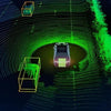
SLAM: Simultaneous Localization and Mapping
SLAM allows devices to localize themselves while building a map in unknown environments.
-
ToF provides accurate depth measurements
-
Point clouds enable spatial structure modeling
-
Critical for robots, autonomous vehicles, and AR devices
Even in GPS-denied areas, ToF-based SLAM supports real-time localization and mapping, ensuring safe navigation.
From Earth to Other Planets: ToF in Planetology
ToF-based LiDAR is essential for:
-
Lunar and Martian terrain mapping
-
Asteroid surface modeling
-
Planetary rover navigation
It converts distant celestial surfaces into measurable 3D spatial models, advancing both space exploration and planetary science.

Mapping as Culture and History
Mapping has historical and cultural significance:
-
Early cartography influenced national symbols and mottos (e.g., New Mexico: Crescit Eundo)
-
Shows the co-evolution of exploration and technology
Conclusion: From Quadrants to ToF Sensors
From early maps and quadrant instruments to modern ToF depth sensors, UAV LiDAR, and SLAM frameworks, distance measurement continues to evolve.
-
ToF integrates high-precision measurement, real-time updates, and full 3D modeling
-
Forms the foundation for digital twins, autonomous navigation, UAV mapping, and industrial spatial perception
-
Demonstrates that technology grows as we move forward—crescit eundo.
autonomous driving robots environment perception and mapping 3D lidar sensor RS-LiDAR-16 RoboSense 16-beam miniature LiDAR

Our professional technical team specializing in 3D camera ranging is ready to assist you at any time. Whether you encounter any issues with your TOF camera after purchase or need clarification on TOF technology, feel free to contact us anytime. We are committed to providing high-quality technical after-sales service and user experience, ensuring your peace of mind in both shopping and using our products.


Please upload banner from store admin blog pages