From Compass to ToF: How Navigation Evolved Before and Beyond GPS
How Did Humans Navigate Before GPS and Evolve to Modern ToF Technology?
Throughout human history, the question 'How do we know where we are and which way to go?' has been one of the most powerful drivers of technological progress. Long before GPS, satellites, or autonomous navigation systems existed, humans relied on natural phenomena, tools, and accumulated knowledge to understand space and direction.
From the earliest compass and ancient maps to today’s TOF (Time-of-Flight) depth sensing, 3D perception, and autonomous navigation systems, humanity’s navigation technology has undergone a series of fundamental transformations. Each leap reflects a deeper understanding of space—from sensing direction to comprehending three-dimensional environments.
This article begins with one of the most frequently searched questions online—'when was the compass invented?'—and traces the evolution of navigation technology from ancient directional tools to modern ToF-based spatial intelligence.
What Is the Time of Flight (ToF) Formula?
At the core of modern depth sensing and spatial perception is the Time-of-Flight (ToF) principle, which calculates distance based on the time it takes a signal to travel to an object and return.
Basic ToF Formula
Distance = (Propagation Speed × Time of Flight) ÷ 2
Or expressed mathematically:
d = v × t / 2
Explanation of Variables
-
d: Distance between the sensor and the target
-
v: Signal propagation speed
-
Optical ToF: speed of light ≈ 3 × 10⁸ m/s
-
Ultrasonic ToF: speed of sound ≈ 343 m/s (in air)
-
-
t: Round-trip travel time of the signal
-
Division by 2: Accounts for the signal traveling to the object and back
This simple formula forms the foundation of ToF depth cameras, LiDAR systems, and modern 3D perception technologies used in robotics and autonomous navigation.

1. The Origin of the Compass: Where Was the Oldest Compass Invented?
Where did the compass come from?
Historical and archaeological research widely agrees that the compass was invented in ancient China. As early as the 4th–3rd century BCE, people discovered that natural magnetite (lodestone) had directional properties.
The earliest known directional instrument was called the Sinan:
-
Spoon-shaped magnet made of lodestone
-
Placed on a smooth bronze plate
-
The handle consistently pointed south
This device is commonly recognized as the world’s oldest compass and the earliest known tool for systematic direction sensing.
2. When Was the Compass Invented?
The question 'when was the compass invented?' has consistently high global search volume, appearing in variations such as:
-
when was compass invented
-
when were compasses invented
-
when was the first compass invented
-
when was the first compass made
Despite phrasing differences, historians largely agree on the timeline.
Key Historical Milestones
-
3rd century BCE (Warring States period)
Early magnetic directional devices (Sinan prototypes) appear -
Northern Song Dynasty (~11th century CE)
Magnetic needle compasses widely used for navigation -
12th–13th century CE
Compass technology spreads to Europe via the Arab world
👉 Conclusion:
The compass was invented in ancient China over 2,000 years ago, marking a major breakthrough in human navigation history.
3. Who Invented the Compass?
Unlike modern inventions, the compass does not have a single inventor.
It emerged through:
-
Long-term observation of magnetic phenomena
-
Gradual refinement by ancient Chinese scholars, craftsmen, and navigators
-
Civilizational-level accumulation of scientific knowledge
Therefore, the most accurate answer to 'who invented the compass?' is:
The compass has no single inventor; it represents the collective wisdom of ancient Chinese civilization.
4. Early Maps and the Compass: Humanity’s First Navigation Systems
Even before the compass, humans created maps to understand their surroundings.
The Oldest Known Maps
-
Mesopotamian clay tablet maps (~2300 BCE)
-
Early Chinese terrain and administrative maps from the Warring States, Qin, and Han periods
📌 Compass + Maps = the earliest human navigation system
However, these early systems had clear limitations:
-
Provided direction, not distance
-
Offered no real-time environmental awareness
-
Relied heavily on experience and static information
5. From Compass to ToF: A Fundamental Shift in Navigation Technology
What Problem Did the Compass Solve?
The compass answered humanity’s most basic navigation question:
'Which direction should I go?'
By indicating north or south, the compass enabled land travel, maritime exploration, and early cartography—independent of stars, sunlight, or landmarks.
-
Core function: Direction sensing
-
Applications: Exploration, navigation, surveying
Yet the compass could not describe spatial structure, obstacles, or surrounding geometry.

What Problem Does ToF Technology Solve?
Modern navigation—especially in robotics, autonomous driving, and smart logistics—demands far more than direction.
ToF technology enables machines to:
-
Measure precise distances
-
Understand depth and spatial structure
-
Build real-time 3D representations of the environment
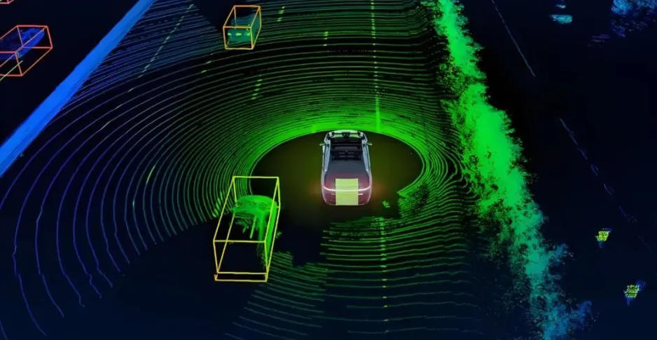
By emitting light pulses and measuring their return time, ToF systems generate depth maps and point clouds that describe the surrounding world.
Key Advantages of ToF:
-
Real-time depth perception
-
Millimeter-level accuracy
-
Strong adaptability to lighting conditions
-
Low dependence on environmental texture
-
Core function: Distance + depth + 3D spatial understanding
-
Applications: Autonomous robots, warehouse navigation, obstacle avoidance, robotic manipulation
In essence, navigation has evolved from knowing where to go to understanding what surrounds you.
6. What Is ToF (Time-of-Flight)? The 'Spatial Compass' of the Modern Era
ToF measures how long light or laser signals take to travel through space, enabling machines to perceive depth.
Common applications include:
-
Mobile robot navigation
-
Near-field perception in autonomous vehicles
-
3D point cloud reconstruction
-
Mapless navigation systems
ToF acts as a modern spatial compass, guiding machines through complex environments.

7. Compass vs. ToF: Two Eras of Navigation Technology
| Dimension | Compass | ToF Technology |
|---|---|---|
| Navigation capability | Direction sensing | 3D spatial perception |
| Real-time awareness | No | Yes |
| Obstacle detection | No | Yes |
| Autonomous decision-making | No | Yes |
| Typical applications | Exploration, navigation | Robotics, autonomous systems |
👉 If the compass gave humans a sense of direction,
👉 ToF gives machines a sense of space.
8. From the Earliest Compass to Mapless Navigation: One Core Question
Whether searching for:
-
earliest compass
-
first compass invented
-
history of the compass
or modern terms like:
-
ToF + SLAM
-
mapless navigation
-
autonomous robots
All address the same timeless question:
'In an unknown world, how do I know where I am and move safely?'
9. Conclusion: The Compass Didn’t Disappear—It Evolved into ToF
The compass was not replaced; it was transformed.
-
From magnet → sensor
-
From direction → spatial modeling
-
From human intuition → machine intelligence
Today, Time-of-Flight technology is becoming the new compass of the intelligent age, empowering robots, autonomous vehicles, and smart systems with real-time 3D understanding of the physical world.
Navigation is no longer about finding north—it’s about understanding space.
Zhisensor D330 Series Industrial 3D Depth Camera – High Precision, Stereo Vision, RGB & Infrared, GigE Interface

After-sales Service: Our professional technical support team specializes in TOF camera technology and is always ready to assist you. If you encounter any issues during the usage of your product after purchase or have any questions about TOF technology, feel free to contact us at any time. We are committed to providing high-quality after-sales service to ensure a smooth and worry-free user experience, allowing you to feel confident and satisfied both with your purchase and during product use.
From Compass to ToF: How Navigation Evolved Before and Beyond GPS


Please upload banner from store admin blog pages