How ToF Cameras and LiDAR Are Used in Archaeology and 3D Mapping
How Are ToF Cameras and LiDAR Used in Archaeology, Surveying, and Point Cloud Processing?
With the rapid advancement of 3D sensing, spatial perception, and digital mapping technologies, TOF (Time-of-Flight) cameras, distance sensors, and LiDAR systems have become foundational tools in archaeology, land surveying, GIS, and point cloud data processing. From LiDAR pyramid scanning and hidden structure detection to digital reconstruction of historical routes and modern cities, these technologies are redefining how humans measure, analyze, and interpret space across time.
Today, the combination of ToF depth sensing, LiDAR point clouds, and advanced data processing algorithms enables non-invasive exploration, high-precision surveying, and scalable 3D digitization—driving innovation across archaeology, geodesy, infrastructure inspection, and digital humanities.
1. What Is Time-of-Flight (ToF) Distance Measurement?
Time-of-Flight (ToF) is a distance measurement method that calculates depth by measuring the time it takes for emitted light to travel to an object and return to the sensor. The fundamental formula is:
Distance = (Speed of Light × Time of Flight) ÷ 2
A ToF camera applies this principle at the pixel level, capturing distance information for every pixel in a single frame. The result is a real-time depth map, making ToF a core category of active distance sensing sensors.
Key advantages of ToF distance measurement include:
-
Instant depth acquisition without multi-frame computation
-
Robust performance under low-texture and low-light conditions
-
High frame rate and low latency for real-time applications
Because of these characteristics, ToF cameras are widely used in robotics, indoor mapping, AR/VR spatial perception, industrial inspection, and embedded 3D vision systems.

2. Types of Distance Sensors and Where ToF Fits
Distance sensing is a cornerstone of 3D perception, robot navigation, UAV surveying, and spatial data acquisition. Common distance sensor technologies include:
ToF Optical Distance Sensors (ToF Cameras)
These sensors measure distance using modulated infrared light and generate per-pixel depth images. They excel in short-to-medium range measurement, real-time interaction, and cost-sensitive deployments.
Typical applications:
-
Indoor robot navigation and SLAM
-
Gesture recognition and human-machine interaction
-
Embedded industrial 3D inspection
-
Digital twin and spatial awareness systems
LiDAR (Light Detection and Ranging)
LiDAR systems emit high-energy laser pulses to measure distance across long ranges, generating high-density 3D point clouds. LiDAR is the industry standard for large-scale, high-precision spatial mapping.
Typical applications:
-
Autonomous driving and ADAS
-
UAV photogrammetry and surveying
-
Smart cities and digital twin platforms
-
Terrain modeling and geospatial analysis
Ultrasonic Distance Sensors
Using sound waves for ranging, ultrasonic sensors are cost-effective but limited in resolution and range. They are suitable for simple obstacle detection, not for 3D modeling or precision surveying.
Millimeter-Wave Radar
mmWave radar uses electromagnetic waves and offers strong environmental robustness. It is widely used in automotive safety, industrial monitoring, and all-weather detection, but lacks fine spatial resolution.
Structured Light Depth Cameras
Structured light systems project patterns to infer depth. They deliver high accuracy at short distances but are sensitive to ambient light and unsuitable for outdoor or large-scale environments.
3. ToF vs. LiDAR: Key Differences and Complementary Roles
Although both ToF and LiDAR are active ranging technologies, their performance profiles differ significantly:
| Feature | ToF Camera | LiDAR |
|---|---|---|
| Measurement Range | Short to medium | Long range |
| Data Output | Depth map | 3D point cloud |
| Accuracy | mm–cm | cm–mm |
| Frame Rate | High, low latency | Lower, scan-dependent |
| Cost | Lower | Higher |
| Typical Use | Indoor perception, interaction | Large-scale surveying |
ToF sensors are ideal for real-time, short-range, embedded 3D perception, while LiDAR excels in long-range, high-precision, outdoor mapping.
Modern systems often integrate ToF + LiDAR + IMU + GNSS, enabling seamless 3D perception across indoor and outdoor environments.

4. LiDAR Applications in Archaeology: Revealing the Invisible
LiDAR archaeology has revolutionized how researchers explore historical sites. Airborne and UAV-mounted LiDAR systems can penetrate vegetation, sand, and surface obstructions, uncovering hidden structures without excavation.
Pyramid LiDAR Scanning
In regions such as Egypt and Central America, LiDAR has been used to:
-
Detect internal pyramid chambers
-
Identify hidden tunnels and voids
-
Build ultra-precise 3D digital models
The resulting LiDAR point cloud data enables archaeologists to perform virtual exploration, structural analysis, and long-term preservation planning.
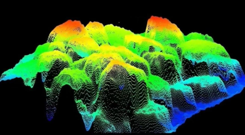
5. Point Cloud Data and Processing Workflows
Point cloud data is the fundamental output of both ToF cameras and LiDAR systems. Each point contains 3D spatial coordinates and may include intensity or RGB color information.
Typical Point Cloud Processing Pipeline
-
Data Acquisition
Capture raw depth maps or laser scans. -
Filtering and Denoising
Remove outliers and reduce noise for accuracy. -
Registration and Alignment
Merge multi-view scans using ICP or feature-based methods. -
3D Reconstruction and Measurement
Generate meshes, surfaces, or voxel models for analysis. -
Visualization and Semantic Analysis
Segment, classify, and interpret spatial data.
Point cloud processing is commonly implemented using Python, C++, PCL, Open3D, or ROS-based frameworks.
These workflows are essential in archaeological reconstruction, infrastructure inspection, historical mapping, and urban planning.

6. Digital Surveying and Historical Geospatial Reconstruction
Historical Geodetic References
Before GPS, physical reference lines like the Washington DC Meridian formed the backbone of early surveying systems. Digitizing these references helps preserve historical coordinate systems.
Digital Reconstruction of Historical Routes
Using LiDAR and ToF data, routes such as El Camino Real can be digitally reconstructed, combining modern spatial sensing with historical research—an emerging field within digital archaeology and digital humanities.
7. Cross-Industry Applications of ToF Technology
Beyond archaeology and surveying, ToF technology plays a vital role in modern industries:
-
Industrial automation and quality inspection
-
Smart manufacturing and mining monitoring
-
Robot navigation and obstacle avoidance
-
3D scanning, digital twins, and asset modeling
Key benefits include:
-
High real-time performance
-
Strong stability in challenging environments
-
Lower cost compared to LiDAR
-
Broad applicability across industries
8. Why ToF Complements the LiDAR Ecosystem
While LiDAR dominates large-scale mapping, ToF cameras fill critical gaps:
-
Lower cost for mass deployment
-
Real-time depth output for dynamic scenes
-
Easy fusion with RGB cameras for RGB-D perception
-
Enhanced close-range interaction and indoor mapping
Together, ToF + LiDAR + point cloud processing form a complete 3D perception ecosystem, supporting applications from autonomous driving and SLAM to digital twins and industrial robotics.
Conclusion
From Time-of-Flight cameras to LiDAR archaeology, from point cloud processing to the digital preservation of historical sites, ToF and LiDAR technologies are jointly driving a new era of spatial understanding.
Whether uncovering hidden pyramid structures, digitizing historical routes, or enabling real-time industrial automation, ToF technology has become an indispensable pillar of modern 3D perception systems—not as a replacement for LiDAR, but as its most powerful complement.
SLAMTEC RPLIDAR A3M1 360° LiDAR Sensor 25M Range, 16000 Samples

After-sales Support:
Our professional technical team specializing in 3D camera ranging is ready to assist you at any time. Whether you encounter any issues with your TOF camera after purchase or need clarification on TOF technology, feel free to contact us anytime. We are committed to providing high-quality technical after-sales service and user experience, ensuring your peace of mind in both shopping and using our products.


Please upload banner from store admin blog pages